How Aerial Landscape Photography Reveals Unique Natural Perspectives
Most of our lives are spent tethered to the ground, perceiving the world at eye level. When we stand before a towering mountain range, a sprawling desert, or a winding river, our vision is inherently limited by the horizon, obscured by the immediate foreground, and bound by the physical constraints of gravity. Traditional landscape photography has spent over a century mastering this perspective, finding beauty in the classic compositional layers of foreground, midground, and background. However, the moment a camera leaves the earth—whether mounted on a drone, strapped to the underside of a helicopter, or held out the window of a bush plane—the visual rules fundamentally change.
Aerial landscape photography is not simply about getting a higher vantage point; it is a translation of the earth into an entirely different visual language. It strips away our terrestrial biases, revealing breathtaking patterns, abstract geometries, and immense natural textures that remain completely invisible to the grounded observer.
Shattering the Ground-Level Illusion
When you shoot a landscape from the ground, you are constantly fighting for depth. You utilize leading lines, wide-angle lenses, and strategically placed foreground elements to trick a two-dimensional medium into feeling three-dimensional. The sky often acts as the ultimate backdrop, providing a sense of scale and atmosphere.
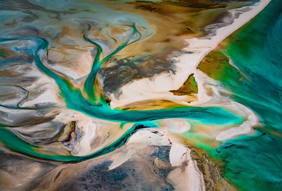
Aerial photography, particularly when shooting straight down in what is known as the nadir view, actively destroys this traditional illusion of depth. When you point a camera directly at the earth from a thousand feet in the air, the sky vanishes from the composition entirely. The ground becomes the entire canvas. This top-down orientation flattens three-dimensional topography into a two-dimensional tapestry, forcing the viewer to appreciate the landscape purely for its graphic qualities rather than its physical depth. Without a horizon line to anchor the eye, the mind is free to wander across the frame, absorbing the environment as a piece of continuous, flowing art.
Discovering Hidden Geometries and Natural Fractals
Nature often appears chaotic and disorganized from the ground. A dense forest is a tangled maze of branches; a coastal marsh is a muddy, impassable expanse; a dried lakebed is just a field of cracked dirt. Yet, when viewed from the sky, this terrestrial chaos instantly organizes itself into profound mathematical order.
The Veins of the Earth
Nowhere is this hidden geometry more apparent than in the planet’s water systems. From the ground, a river is simply a body of moving water cutting through the landscape. From the air, an entirely new structural reality emerges. Braided glacial rivers, like those found carving their way through the volcanic ash of Iceland, spread out into incredibly complex, branching networks. From a high altitude, these glacial runoffs look identical to the delicate neural pathways of the human brain or the vascular system pumping blood through a living organism. The realization that a microscopic biological structure and a massive geological river system share the exact same fractal geometry is a perspective that only aerial photography can provide.
Topographical Textures
Altitude also transforms massive geographical features into tactile textures. Consider the sprawling sand dunes of a vast desert. Walking among them, they are imposing mountains of sand that dominate the skyline. But when photographed from a high elevation, those massive peaks are flattened into delicate, sweeping ridges that resemble the wrinkles on the palm of a hand or the fine scales of a reptile. Similarly, the dense canopy of an autumn forest, chaotic from below, morphs into a vibrant, pointillist painting composed of millions of individual, colorful dots.
The Mastery of Scale and Abstraction
One of the most fascinating psychological aspects of aerial photography is visual ambiguity. Human beings rely on familiar reference points to understand the size of the world around them. We use the height of a person, the size of a tree, or the recognizable shape of a building to calculate the scale of a photograph instantly.
When you remove the horizon and shoot straight down onto an uninhabited landscape, you strip away all of these terrestrial reference points. Without familiar context, the human brain struggles to comprehend scale, resulting in a mesmerizing sense of visual disorientation. A photograph of a massive, frozen glacial lake can easily be mistaken for a microscopic slide of crystallizing minerals or a close-up of shattered glass. A tidal flat carved by receding ocean water might look exactly like a macro photograph of a leaf’s skeleton.
By removing scale, the aerial photographer forces the viewer to engage with the landscape as an abstract painting. The image is no longer about a specific location on a map; it becomes an exploration of color theory, leading lines, and organic shapes. This abstraction is what elevates aerial imaging from simple geographical documentation into a highly sophisticated form of fine art.
Chasing Light and Shadow from the Sky
Light behaves entirely differently when you are observing the earth from the sky, fundamentally altering how textures are captured on a camera sensor. Ground-based photographers relentlessly chase the golden hour—the brief windows of time just after sunrise and just before sunset—because the soft, diffused light flatters the landscape.
For the aerial photographer, the golden hour serves a much more structural purpose: the manipulation of shadow. When the sun hangs low on the horizon, it rakes harsh light across the topography. From the ground, this means shooting directly into a blinding sun or dealing with heavily backlit, silhouetted subjects. From the air, looking straight down, this low-angle light casts long, dramatic shadows across every raised surface on the earth.
A seemingly flat expanse of badlands suddenly reveals deep, undulating crevices as the shadows fill the canyons. The subtle ripples of a sandbar in a shallow ocean are suddenly defined by high-contrast ridges. Aerial photography relies on these shadows to carve texture out of flatness, using the angle of the sun to reveal the hidden topography that midday light completely washes away.
The Environmental Narrative: Seeing the Bigger Picture
Beyond pure aesthetic abstraction and structural beauty, altitude offers an undeniable, objective truth about the state of our planet. You simply cannot see the full scope of a shifting coastline, the sprawling impact of a drought, or the relentless march of deforestation from standing on the ground.
Aerial photography provides critical macro-level context. It shows the stark, razor-sharp dividing lines between a protected, lush green forest and a barren, clear-cut logging zone. It reveals the mesmerizing but alarming neon-green blooms of toxic algae spreading across a warming lake, or the intricate, dry scars left behind by a receding reservoir. By presenting these environmental realities from a perspective that captures the entire scope of the landscape, aerial photographers provide a powerful visual narrative that grounds abstract climate statistics in undeniable reality.
Elevating a camera into the sky does far more than just capture a wider field of view. It shatters the visual conditioning we have developed from a lifetime of walking on the ground. Aerial landscape photography challenges our perception of the spaces we inhabit, turning massive geological formations into microscopic textures and chaotic wilderness into organized geometry. It proves that the earth is not just a collection of landscapes to stand upon, but a breathtaking, living canvas waiting to be deciphered from above.